NLB operating history
Read the official light chronology; its journal photographs are cited but not republished.
Open media sourceHeritage Journey
What happens when a navigation light is fixed to a rock whose warning, sovereignty and surrounding sea rights do not share one legal answer?
Follow Rockall's warning from the Norge disaster to the 1972 light, its failure and delisting, and the legal questions that outlived it.
Story mode is the guided heritage-continuity mode inside the LUX Light Archive renderer.
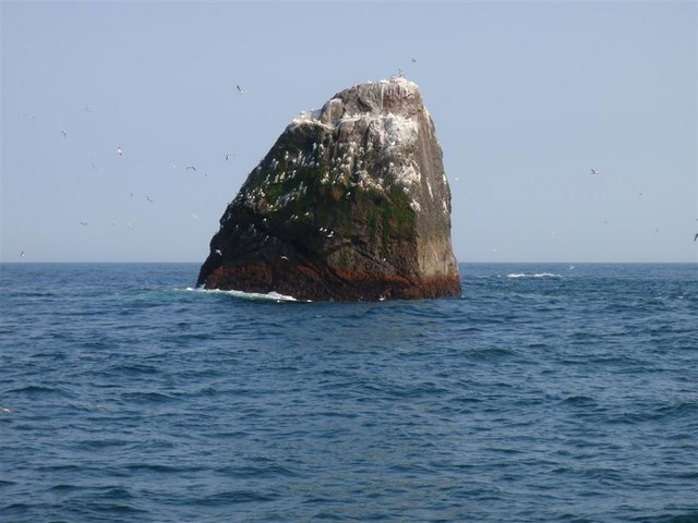
Rockall, photographed by Andy Strangeway on 14 May 2008 · CC BY-SA 2.0 · Source
Signature moment
One small apparatus could mark a hazard; it could not settle sovereignty, fisheries enforcement or the continental shelf.
Conceptual illustration only — not to scale.
The journey
Verified fact
After the steamship Norge struck the reefs near Rockall in 1904 and more than 600 people died, David A. Stevenson argued that the hazard should be marked by a powerful self-contained lightship. No light followed.
Verified fact
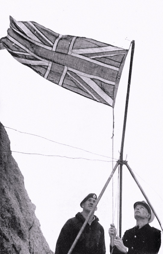
The United Kingdom formally claimed Rockall on 18 September 1955. Parliamentary debate later placed the act within guided-weapons-range security concerns; Ireland does not recognise British sovereignty over the rock.
Verified fact
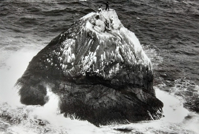
A military-supported expedition reduced the summit to make a platform. The government navigation light was first lit on 27 June 1972: a warning device fixed to a place already carrying a territorial claim.
Verified fact
A 1982 operation replaced batteries and damaged equipment, but the light had failed again by March 1983. By November 1984 no further attempt to relight it was planned.
Verified fact
UNCLOS Article 121 denies an exclusive economic zone or continental shelf to rocks unable to sustain human habitation or economic life of their own. In 1997 the United Kingdom relinquished the Rockall Fisheries Zone: the rock does not generate a 200-mile UK EEZ.
Verified fact
After later studies found restoration and servicing disproportionate, NLB advised removal of the Rockall light from the Admiralty List of Lights in 2006. The site remained; the listed signal did not.
Verified fact
The United Kingdom's sovereignty claim, Ireland's non-recognition, enforcement within a claimed 12-mile zone, and overlapping Hatton–Rockall continental-shelf submissions are related but legally distinct. The archive records those positions without deciding them.
Video
Read the official light chronology; its journal photographs are cited but not republished.
Open media sourceRead the geology and installation expedition account with its OGL image.
Open media sourceAcross time
The NLB coordinate is a site reference. Conceptual beats describe legal change without drawing maritime boundaries or deciding title.
Loading detailed map...
RockallStage 1
After the steamship Norge struck the reefs near Rockall in 1904 and more than 600 people died, David A. Stevenson argued that the hazard should be marked by a powerful self-contained lightship. No light followed.
Why it matters
Rockall shows why maritime heritage and maritime law must not be collapsed into a slogan: a warning light, a sovereignty claim, a fisheries enforcement zone and continental-shelf submissions answer different questions.
The Story and Research views share one URL and the same evidence boundary.
Heritage Journey
What happens when a navigation light is fixed to a rock whose warning, sovereignty and surrounding sea rights do not share one legal answer?
Rockall's short-lived navigation light connects a lethal maritime hazard, a Cold War territorial act, extreme maintenance, UNCLOS limits and continuing fisheries disputes without turning those distinct histories into one claim.
LUX Light Archive is the heritage renderer of the LUX143 research field, preserving lighthouse continuity through evidence, memory, movement, and sources.
Understand how this archive fits into the wider research field.
Inside this heritage renderer, Story and Research are two modes of the same evidence-grounded journey: Story gives a guided path, while Research shows the sources, relationships, uncertainty, and open questions behind it.
Verified fact
A wreck turns the rock into a warningAfter the steamship Norge struck the reefs near Rockall in 1904 and more than 600 people died, David A. Stevenson argued that the hazard should be marked by a powerful self-contained lightship. No light followed.
Verified fact
A flag is raised in the missile-age AtlanticThe United Kingdom formally claimed Rockall on 18 September 1955. Parliamentary debate later placed the act within guided-weapons-range security concerns; Ireland does not recognise British sovereignty over the rock.
Verified fact
The summit is cut and a light is litA military-supported expedition reduced the summit to make a platform. The government navigation light was first lit on 27 June 1972: a warning device fixed to a place already carrying a territorial claim.
Verified fact
Repair gives way to abandonmentA 1982 operation replaced batteries and damaged equipment, but the light had failed again by March 1983. By November 1984 no further attempt to relight it was planned.
Verified fact
The 200-mile inference is withdrawnUNCLOS Article 121 denies an exclusive economic zone or continental shelf to rocks unable to sustain human habitation or economic life of their own. In 1997 the United Kingdom relinquished the Rockall Fisheries Zone: the rock does not generate a 200-mile UK EEZ.
Verified fact
The failed light leaves the official listAfter later studies found restoration and servicing disproportionate, NLB advised removal of the Rockall light from the Admiralty List of Lights in 2006. The site remained; the listed signal did not.
Verified fact
One rock, four different legal questionsThe United Kingdom's sovereignty claim, Ireland's non-recognition, enforcement within a claimed 12-mile zone, and overlapping Hatton–Rockall continental-shelf submissions are related but legally distinct. The archive records those positions without deciding them.
Follow Rockall's warning from the Norge disaster to the 1972 light, its failure and delisting, and the legal questions that outlived it.
Rockall shows why maritime heritage and maritime law must not be collapsed into a slogan: a warning light, a sovereignty claim, a fisheries enforcement zone and continental-shelf submissions answer different questions.
The Story and Research views share one URL and the same evidence boundary.
Connected research view
Select an event, object, or place to trace it across all three views.
After the steamship Norge struck the reefs near Rockall in 1904 and more than 600 people died, David A. Stevenson argued that the hazard should be marked by a powerful self-contained lightship. No light followed.
The United Kingdom formally claimed Rockall on 18 September 1955. Parliamentary debate later placed the act within guided-weapons-range security concerns; Ireland does not recognise British sovereignty over the rock.
A military-supported expedition reduced the summit to make a platform. The government navigation light was first lit on 27 June 1972: a warning device fixed to a place already carrying a territorial claim.
A 1982 operation replaced batteries and damaged equipment, but the light had failed again by March 1983. By November 1984 no further attempt to relight it was planned.
UNCLOS Article 121 denies an exclusive economic zone or continental shelf to rocks unable to sustain human habitation or economic life of their own. In 1997 the United Kingdom relinquished the Rockall Fisheries Zone: the rock does not generate a 200-mile UK EEZ.
After later studies found restoration and servicing disproportionate, NLB advised removal of the Rockall light from the Admiralty List of Lights in 2006. The site remained; the listed signal did not.
The United Kingdom's sovereignty claim, Ireland's non-recognition, enforcement within a claimed 12-mile zone, and overlapping Hatton–Rockall continental-shelf submissions are related but legally distinct. The archive records those positions without deciding them.
The graph separates Rockall as a landscape feature, its navigation-site continuity and the 1972 navigation sign. Legal positions remain attributed evidence, not graph facts of sovereignty.
No path selected.
The NLB coordinate is a site reference. Conceptual beats describe legal change without drawing maritime boundaries or deciding title.
Loading detailed map...
RockallStage 1
After the steamship Norge struck the reefs near Rockall in 1904 and more than 600 people died, David A. Stevenson argued that the hazard should be marked by a powerful self-contained lightship. No light followed.
Official and object-specific sources carry the strongest confidence; secondary sources are shown as corroborating context.
Research still in progress — these do not affect accepted relationships above.
A photograph of a rock cannot show the short operational life of its navigation light or the legal limits of what the rock can generate at sea.
LUX keeps place, apparatus, physical change, attributed state positions and unresolved questions separate while making their connection readable.
Original editorial content on this page: Creative Commons Attribution-NonCommercial-ShareAlike 4.0 International. See Rights & Reuse.
"Rockall: A Light Between Warning and Claim" · rockall-light-between-warning-and-claim · © LUX143 · Creative Commons Attribution-NonCommercial-ShareAlike 4.0 International · https://light.lux143.org/heritage-journeys/rockall-light-between-warning-and-claim/ Union Flag raised on Rockall, 18 September 1955 · Rights status: Public Domain · Public domain (https://creativecommons.org/publicdomain/mark/1.0/) Expedition members scaling Rockall, photographed during 1971–72 · Rights status: Used with permission · Open Government Licence 3.0 (https://www.nationalarchives.gov.uk/doc/open-government-licence/version/3/)
LUX Light Archive, Heritage journey: "Rockall: A Light Between Warning and Claim", rockall-light-between-warning-and-claim, https://light.lux143.org/heritage-journeys/rockall-light-between-warning-and-claim/, accessed 2026-09-17, archive v0.24.571.