Continuity site
Morris Island Light site
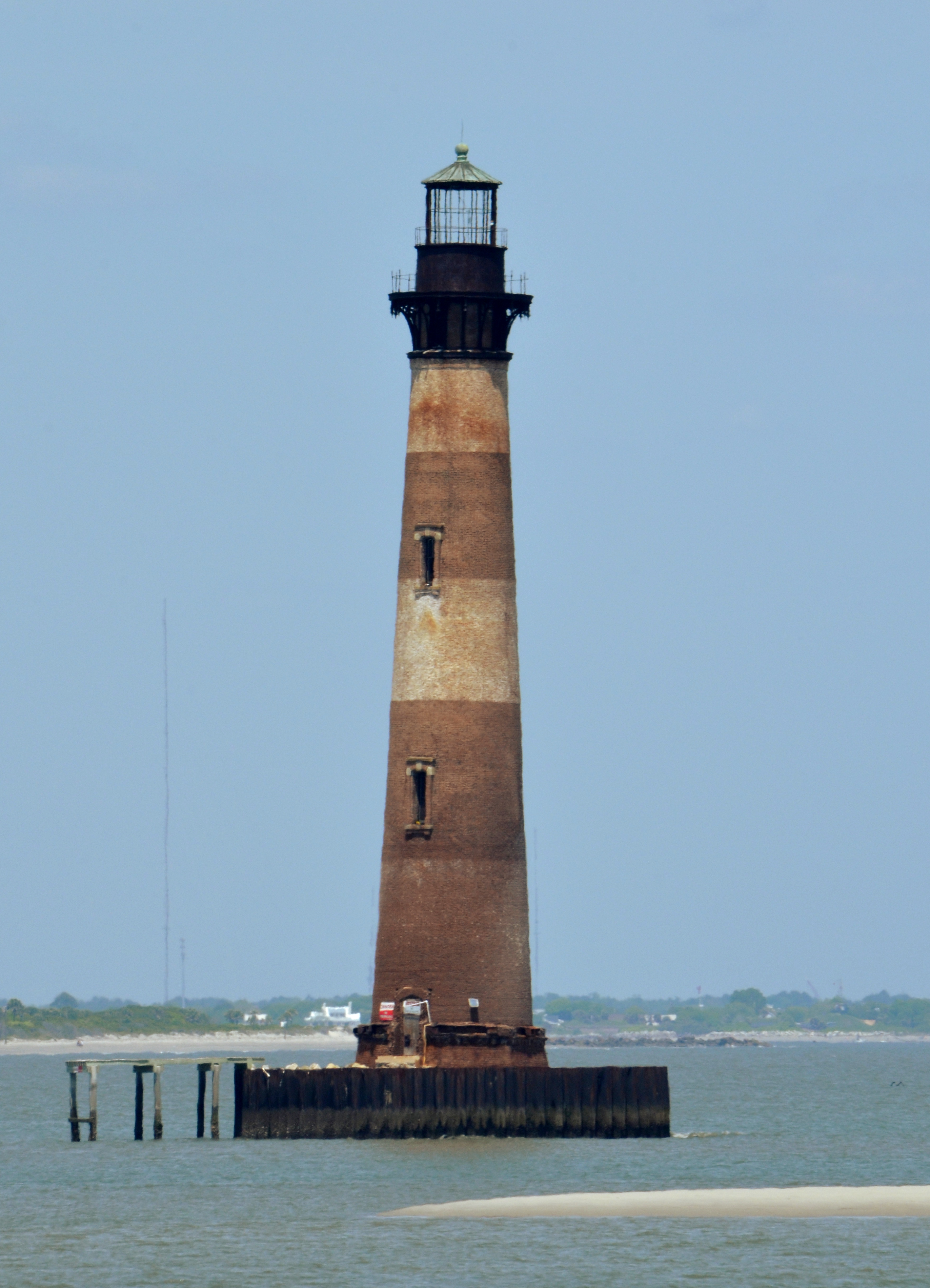
Morris Island Light began inland of the shoreline; jetties altered currents, erosion reached the tower, the station was decommissioned, and Charleston Light replaced it — leaving an offshore ruin as memory.
Heritage Journey
Erosion ended the station while the tower remained offshore
A classic Lost Light: navigation ended, the tower stayed.
Story mode is the guided heritage-continuity mode inside the LUX Light Archive renderer.
Morris Island Light standing offshore after shoreline erosion, April 2014. — Niagara / Wikimedia Commons · CC BY-SA 3.0 · Source
Signature moment
Conceptual illustration only — not to scale.
The journey
Probable reconstruction
The tower was constructed far from the water's edge on a larger Morris Island.
Probable reconstruction
Harbor jetties altered ocean currents and accelerated island erosion.
Probable reconstruction
By the late 1930s the shore had reached the light, forcing automation as staffing became impractical.
Probable reconstruction
Morris Island Light was decommissioned and replaced by Charleston Light on Sullivan's Island.
Place
Mapped point is a research lead only; confirm coordinates before public release.
Loading detailed map...
Morris Island Light siteStage 1
The tower was constructed far from the water's edge on a larger Morris Island.
Place
Continuity site
Morris Island Light began inland of the shoreline; jetties altered currents, erosion reached the tower, the station was decommissioned, and Charleston Light replaced it — leaving an offshore ruin as memory.
Why it matters
Morris Island Light began inland of the shoreline; jetties altered currents, erosion reached the tower, the station was decommissioned, and Charleston Light replaced it — leaving an offshore ruin as memory.
This pilot stays hidden from public discovery until evidence, rights, and AAA Story review are complete.
Heritage Journey
Erosion ended the station while the tower remained offshore
Morris Island Light began inland of the shoreline; jetties altered currents, erosion reached the tower, the station was decommissioned, and Charleston Light replaced it — leaving an offshore ruin as memory.
LUX Light Archive is the heritage renderer of the LUX143 research field, preserving lighthouse continuity through evidence, memory, movement, and sources.
Understand how this archive fits into the wider research field.
Inside this heritage renderer, Story and Research are two modes of the same evidence-grounded journey: Story gives a guided path, while Research shows the sources, relationships, uncertainty, and open questions behind it.
Probable reconstruction
Built back from the waterThe tower was constructed far from the water's edge on a larger Morris Island.
Probable reconstruction
Jetties change the currentsHarbor jetties altered ocean currents and accelerated island erosion.
Probable reconstruction
Shoreline reaches the towerBy the late 1930s the shore had reached the light, forcing automation as staffing became impractical.
Probable reconstruction
Decommissioned and replacedMorris Island Light was decommissioned and replaced by Charleston Light on Sullivan's Island.
A classic Lost Light: navigation ended, the tower stayed.
Morris Island Light began inland of the shoreline; jetties altered currents, erosion reached the tower, the station was decommissioned, and Charleston Light replaced it — leaving an offshore ruin as memory.
This pilot stays hidden from public discovery until evidence, rights, and AAA Story review are complete.
Connected research view
Select an event, object, or place to trace it across all three views.
The tower was constructed far from the water's edge on a larger Morris Island.
Harbor jetties altered ocean currents and accelerated island erosion.
By the late 1930s the shore had reached the light, forcing automation as staffing became impractical.
Morris Island Light was decommissioned and replaced by Charleston Light on Sullivan's Island.
Graph links lighthouse identity, fabric, place, and dated transformation leads.
No path selected.
Mapped point is a research lead only; confirm coordinates before public release.
Loading detailed map...
Morris Island Light siteStage 1
The tower was constructed far from the water's edge on a larger Morris Island.
Official and object-specific sources carry the strongest confidence; secondary sources are shown as corroborating context.
| Relationship | Objects | Date | Confidence | Review | Sources |
|---|---|---|---|---|---|
| Located atHERITAGE-REL-000244Appears in Story: Built back from the water · Appears in Story: Jetties change the currents · Appears in Story: Shoreline reaches the tower · Appears in Story: Decommissioned and replaced | Morris Island Light towertoMorris Island Light site | 1876 | medium | reviewed | Morris Island Lighthouse — Wikipedia |
Research still in progress — these do not affect accepted relationships above.
A map pin labeled inactive cannot show that the island moved and the light stayed.
LUX is for heritage that is no longer obvious: an offshore tower that still marks a vanished shoreline relationship.
Original editorial content on this page: Creative Commons Attribution-NonCommercial-ShareAlike 4.0 International. See Rights & Reuse.
"Morris Island: When the Shoreline Left the Light" · morris-island-lost-offshore · © LUX143 · Creative Commons Attribution-NonCommercial-ShareAlike 4.0 International · https://light.lux143.org/heritage-journeys/morris-island-lost-offshore/ Morris Island Light standing offshore after shoreline erosion, April 2014. — Niagara / Wikimedia Commons · Rights status: CC BY-SA · CC BY-SA 3.0 (https://creativecommons.org/licenses/by-sa/3.0/) · © Niagara
LUX Light Archive, Heritage journey: "Morris Island: When the Shoreline Left the Light", morris-island-lost-offshore, https://light.lux143.org/heritage-journeys/morris-island-lost-offshore/, accessed 2026-09-17, archive v0.24.571.